Geography of Badahat Uttarkashi
Natural landscape, terrain, and environmental features of the region
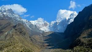
Location & Terrain
Badahat Uttarkashi is located in the northern part of Uttarakhand state in India and lies within the Garhwal Himalayan region. The town is situated along the banks of the Bhagirathi River and surrounded by high mountain ranges, valleys, forests, and rocky terrain. Its elevation and mountainous geography give the region a cool climate and scenic natural environment.
The municipal area features uneven topography, narrow plains, and steep slopes, making urban planning and infrastructure development unique and challenging. Seasonal rivers, dense forests, and natural springs form an integral part of the local ecosystem and water supply system.
Region
Garhwal Himalayas
Elevation
Approx. 1,158 meters
River
Bhagirathi River
Terrain
Mountainous & Valley Regions
Climate Overview
Summer
Pleasant and mild with moderate temperatures.
Monsoon
Heavy rainfall influencing landslides and river flow.
Winter
Cold weather with occasional snowfall in nearby areas.
Geographical Overview
Elevation
≈ 1158 meters above sea level
Latitude
30.73° N
Longitude
78.45° E
Terrain
Mountainous Himalayan Region